Mexico City visitor guide
Plan separate historic-center and Chapultepec days and compare train or bus approaches from Mexico City’s airports.

Build your first visit around two areas: the historic center and Chapultepec. A Zócalo base works for early starts in the center; a hotel near Reforma lets you split time between downtown and the park. Keep at least one afternoon unbooked for a market or neighborhood that catches your attention.
What to see
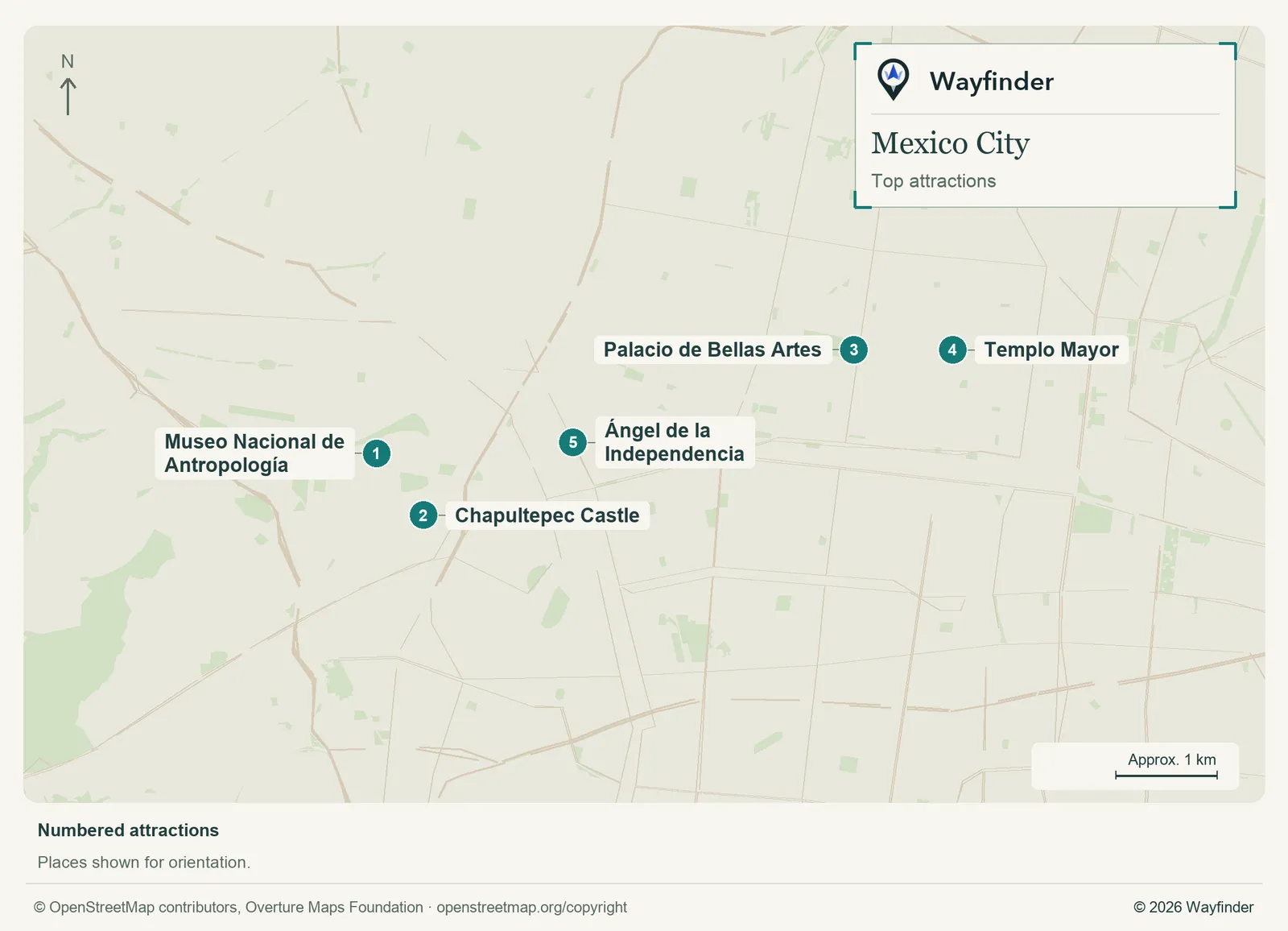
Map: Wayfinder. Map data © OpenStreetMap contributors, Overture Maps Foundation (OpenStreetMap copyright, Overture attribution).
Open attractions map (SVG, full detail)

- Museo Nacional de Antropología. Give the museum most of a morning or longer and choose a few halls before entering. The park can absorb whatever time you have left. (INAH Anthropology Museum, checked November 20, 2026)
- Chapultepec Castle. Plan the approach up the hill and check the museum’s own admission details. Put it on another day if you want time at the anthropology museum. (Mexico City Tourism: Chapultepec Castle, checked November 20, 2026)
- Palacio de Bellas Artes. Decide whether you want the building exterior, the museum or a performance. Each calls for a different amount of time. (Mexico City Tourism: Palacio de Bellas Artes, checked November 20, 2026)
- Templo Mayor. Start the historic-center day with the archaeological site or museum. Follow with time around the Zócalo rather than a rush to a different district. (INAH Templo Mayor, checked November 20, 2026)
- Ángel de la Independencia. Use it as a Reforma reference point and give the surrounding streets a purpose, such as lunch in the area. (Mexico City Tourism: Ángel de la Independencia, checked November 20, 2026)
Where to stay
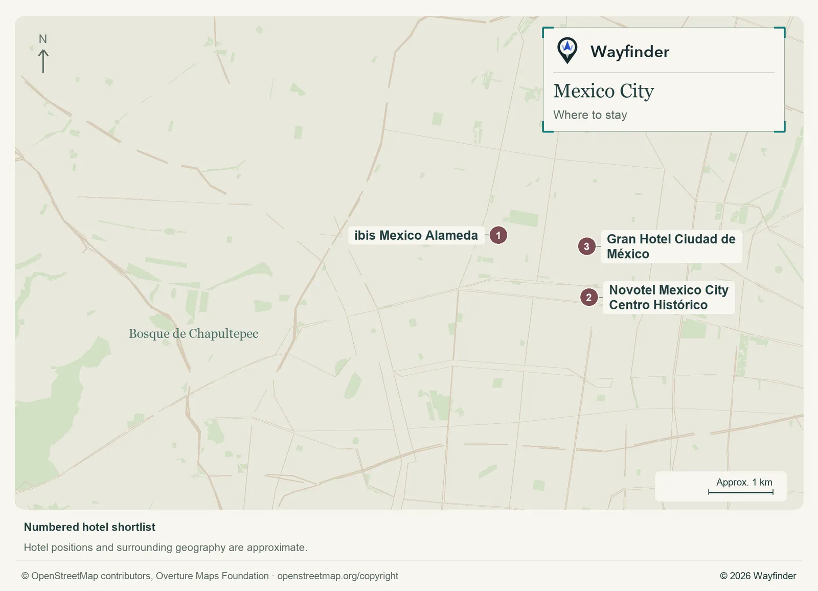
Map: Wayfinder. Map data © OpenStreetMap contributors, Overture Maps Foundation (OpenStreetMap copyright, Overture attribution).
Open hotels map (SVG, full detail)

- ibis Mexico Alameda (Alameda · value). A three-star base between the Alameda Central and Reforma, about a 20-minute walk from the Zócalo. Compare rooms away from the street. (ibis Mexico Alameda, checked November 20, 2026)
- Novotel Mexico City Centro Histórico (Centro Histórico · midrange). A four-star hotel on Avenida 20 de Noviembre, south of the Zócalo. A practical base for the main square and an early Templo Mayor visit. (Novotel Mexico City Centro Histórico, checked November 20, 2026)
- Gran Hotel Ciudad de México (Zócalo · splurge). Choose it when the main square is part of the experience. Verify which room categories face the square and what is happening there on your dates. (Gran Hotel Ciudad de México, checked November 20, 2026)
Getting in and around
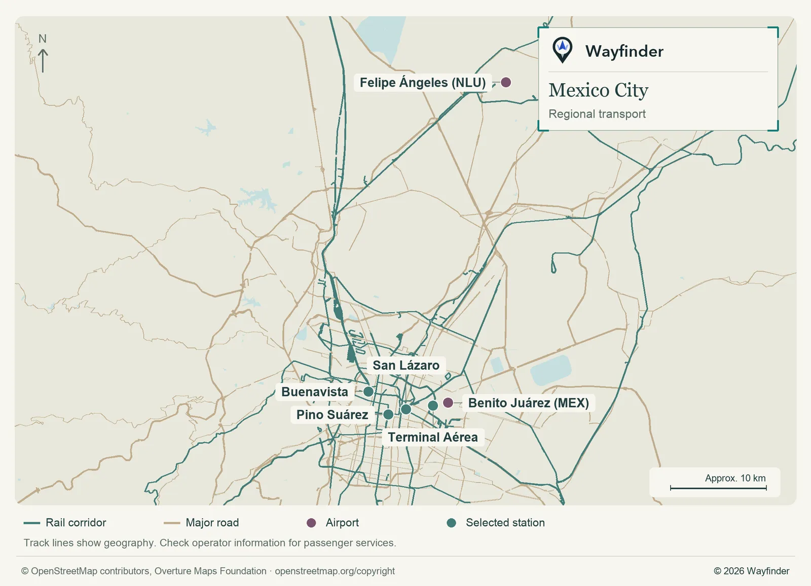
Map: Wayfinder. Map data © OpenStreetMap contributors, Overture Maps Foundation (OpenStreetMap copyright, Overture attribution).
Open regional transport map (SVG, full detail)

Check if you are landing at Benito Juárez or Felipe Ángeles. At Benito Juárez, consult the airport’s current Metrobús information and check the boarding point for your terminal. Felipe Ángeles is farther out. The airport lists the Tren Felipe Ángeles connection to Buenavista. Compare the scheduled train and onward city trip against the other ground options before choosing a flight. (AICM Metrobús, checked November 20, 2026) (Felipe Ángeles Airport train, checked November 20, 2026)
Use the city Metro and Metrobús planners for ordinary trips. Terminal Aérea on the map is a useful reference near Benito Juárez Terminal 1. For trips across the city, compare how many changes you need with the road route at the time you plan to travel. (Mexico City Terminal Aérea, checked November 20, 2026)
Airport to city options
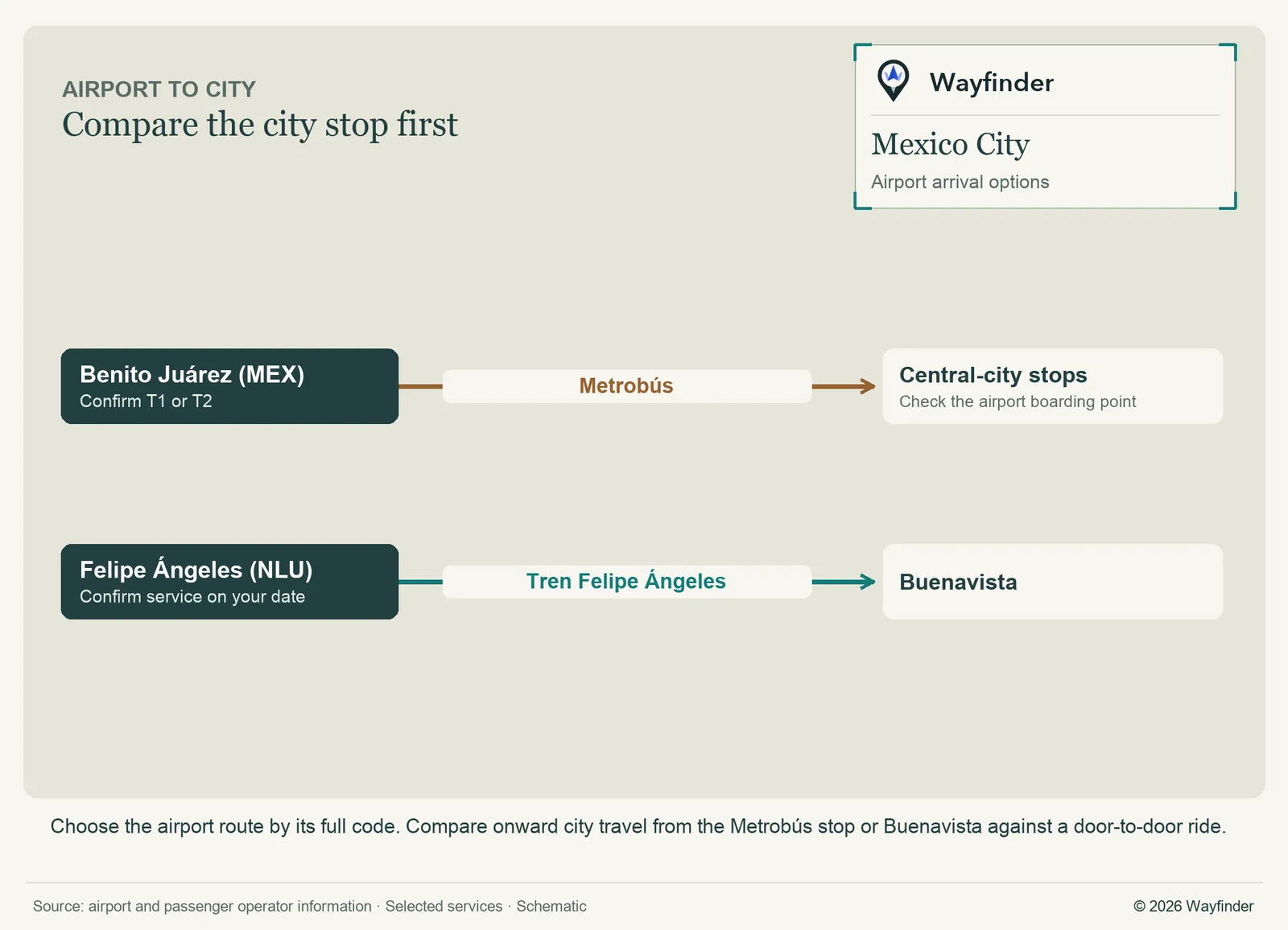
Map: Wayfinder. Map data © OpenStreetMap contributors, Overture Maps Foundation (OpenStreetMap copyright, Overture attribution).
Open airport arrivals map (SVG, full detail)

How to use three days
Put Templo Mayor and Bellas Artes into one historic-center day. Give the anthropology museum and park the next one. Use a third day for the castle or a Reforma walk and dinner, choosing the one you want more time to explore.
Choose where to spend the museum time
At the anthropology museum, write down the two halls most important to you before arriving. Leave the castle or a long park outing conditional on how much energy is left. Save the historic-center museum day for separate opening hours rather than trying to fit both areas into a tight afternoon.
Common questions
Can I use the same transfer plan for both airports?
No. Compare each airport separately, including the last ride to your hotel and the return time for an early flight.
Can I see the park and the historic center in one day?
Choose one anchor in each if you must. Both have enough to fill a day when you include the museums.
Sources
- INAH Anthropology Museum, checked November 20, 2026.
- Mexico City Tourism: Chapultepec Castle, checked November 20, 2026.
- Mexico City Tourism: Palacio de Bellas Artes, checked November 20, 2026.
- Mexico City Tourism: Ángel de la Independencia, checked November 20, 2026.
- INAH Templo Mayor, checked November 20, 2026.
- ibis Mexico Alameda, checked November 20, 2026.
- Novotel Mexico City Centro Histórico, checked November 20, 2026.
- Gran Hotel Ciudad de México, checked November 20, 2026.
- AICM Metrobús, checked November 20, 2026.
- Felipe Ángeles Airport train, checked November 20, 2026.
- Mexico City Terminal Aérea, checked November 20, 2026.